The rate at which ice is disappearing across the planet is speeding up, according to research funded by the Natural Environment Research Council. The findings also reveal that the Earth lost 28 trillion tonnes of ice between 1994 and 2017 – equivalent to a sheet of ice 100m thick covering the whole of the UK.
Scientists led by the University of Leeds found that the rate of ice loss from the Earth has increased markedly within the past three decades, from 0.8 trillion tonnes per year in the 1990s to 1.3 trillion tonnes per year by 2017. Ice melt across the globe raises sea levels, increases the risk of flooding to coastal communities, and threatens to wipe out natural habitats that wildlife depends on.
Global sea levels rising
Half of all losses were from ice on land – including 6.1 trillion tonnes from mountain glaciers, 3.8 trillion tonnes from the Greenland ice sheet, and 2.5 trillion tonnes from the Antarctic ice sheet. These losses have raised global sea levels by 35mm. It is estimated that for every centimetre of sea level rise, approximately a million people are in danger of being displaced from low-lying homelands. Despite storing only 1% of the Earth’s total ice volume, glaciers have contributed to almost a quarter of the global ice losses over the study period, with all glacier regions around the world losing ice.
As well as contributing to global mean sea level rise, mountain glaciers are also critical as a freshwater resource for local communities. The retreat of glaciers around the world is therefore of crucial importance at both local and global scales. Just over half (58%) of the ice loss was from the northern hemisphere, and the remainder (42%) was from the southern hemisphere.
What follows is a study of two glacial areas which show different aspects of glacial ice loss.
1. Desolation Lake and Lituya Bay, Alaska
Lituya Bay is best known among geologists for a landslide in 1958 that slammed into its waters and triggered one of the largest tsunami waves known. But that is not the only dramatic geologic phenomenon lurking in this glacier-sculpted fjord in south-eastern Alaska.
In August 2020, a commercial fisherman noticed a surprisingly strong current of muddy water, trees, and chunks of ice rushing against the tide near the head of the bay. He alerted a geologist at the National Park Service, and a small team of researchers has pieced together what likely caused the surge of floodwater. A huge lake that had been dammed by Lituya Glacier drained abruptly in mid-August. [Events like these are known as glacial lake outburst floods (GLOFs), or sometimes jökulhlaups.]
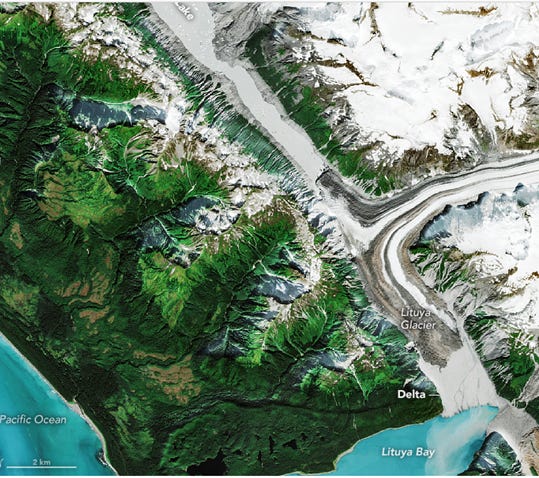
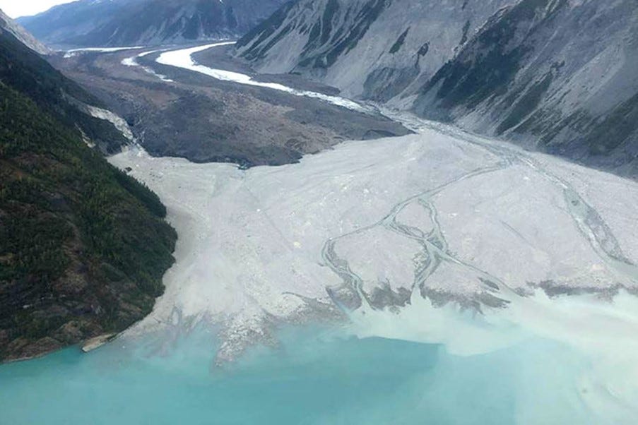
The pair of images below highlights changes caused by the flood. Notice how much lower Desolation Lake stood on September 6, 2020, than on July 1, 2020. Also, the stream channels that run through the delta and into Lituya Bay shifted significantly, with a few small lakes filled with gravel. The aerial photograph taken on September 17, 2020, shows the delta after it had been altered by the flood.
It appears that this massive outburst flood travelled underneath the Lituya Glacier, emerging from under its south end onto the gravel delta that now separates the glacier from Lituya Bay. The lake level dropped at least 60m, implying a total flood volume of about half a cubic kilometre of water. The amount of sediment pushed out from under the glacier by these events is substantial, over 10 million cubic metres. That has been enough to build a broad delta over parts of the bay that were 100m deep only a few decades ago.
July 1st 2020
Photo: NASA
September 6th 2020
Photo: NASA
Aerial photograph Sept 17th 2020
2. Ålfotbreen glacier, Norway
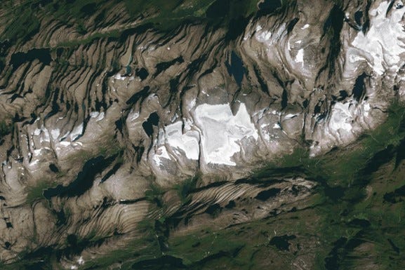
Ålfotbreen glacier lies above the fjords of Norway’s western coast. The ice cap is vulnerable to changing temperatures and has been in decline since the late 1990s. Ålfotbreen is Norway’s 25th largest glacier. The glacier sees dramatic swings in its surface mass between winter and summer. This is partly due to its location along the western coast, which receives about 600cm of annual precipitation, making it one of the wettest places in Europe. Ålfotbreen gains mass as snow accumulates over winter and loses mass as it melts over summer. Heatwaves melt snow cover earlier in the season, which exposes darker icy surfaces earlier and accelerates melting. Although snowy winters led to the ice cap’s growth between 1989 and 1995, more frequent and intense heatwaves have since contributed to the glacier’s decline.
Between 2013 and 2022, the World Glacier Monitoring Service reports that Ålfotbreen lost an average of 1.07 metres water equivalent each year. In about half of the summers over the past two decades, no fresh snow cover remained on the glacier at the end of the melt season. The lack of a persistent accumulation zone suggests that the glacier may not survive with climate change.
Ålfotbreen glacier
Photo: NASA


