


Satellite stories - 1
Carriacou and Hurricane Beryl

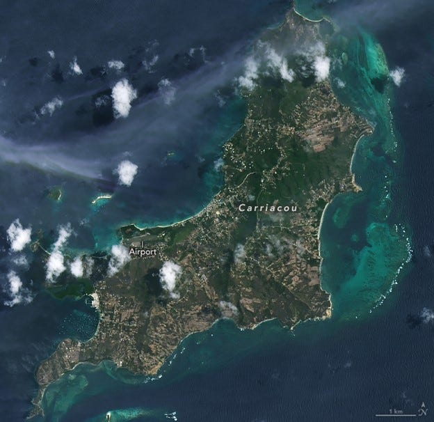
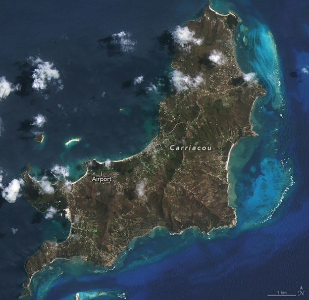
Carriacou is an island of the Grenadine Islands. It is a part of the nation of Grenada, located in the south-eastern Caribbean Sea, northeast of the island of Grenada and the north coast of South America. It was badly affected by Hurricane Beryl in July 2024 (see satellite images below – before and after).
Before: June 20th, 2024
After: July 6th 2024
Source: NASA
Hurricane Beryl made landfall on Carriacou as a Category 4 storm on the morning of July 1st 2024. With maximum winds of 240 km per hour, the storm damaged practically all of the buildings on the island and affected all of the population. Rough seas and air control tower outages hindered aid responses immediately after the storm.
After crossing the Grenadine islands, the hurricane swept westwards across the Caribbean, where it brought strong winds and dangerous storm surge to Jamaica and Mexico’s Yucatan Peninsula before making landfall in Texas as a Category 1 storm. Beryl flooded streets, tore roofs off homes, and knocked out power and communications for millions of people along its path. The death toll for the event was surprisingly low. Sources suggest it was 11 for the whole region.
On Carriacou the powerful storm devastated forests. In the satellite photographs above, many areas that were dark green before the hurricane had turned brown in its aftermath. Note that built-up portions of the island appear less defined in the post-hurricane image, which may be due to flooding and debris from damaged infrastructure.
Hurricanes disturb both temperate and tropical forests in this region. High winds blow leaves off trees and snap branches, and when combined with heavy rain, they more easily uproot trees from saturated soils.
Carriacou’s vegetation consists primarily of deciduous and dry thorn-scrub forests. Due to the island’s relatively low topographic relief, little of the plant life has been spared from Beryl’s raging winds. It is likely that all the vegetation would have been defoliated. The brown seen in the later image is exposed wood.
Changes to mangrove stands on the coast of Carriacou are also evident. Mangroves are networks of saltwater-tolerant trees and shrubs that help prevent coastal erosion, absorb carbon from the atmosphere, and provide habitat for fish and other marine animals. Such extreme storms defoliate and uproot mangrove trees, block drainage to the ocean, and cause flooding that affects soil oxygen concentrations and hinders photosynthesis.
The images can be downloaded here.