Satellite stories - 10
The links between current rural landscapes in Poland and past landscapes in the UK

Field patterns in southern Poland
Over centuries, in southern Poland, as elsewhere in Europe, settlements have clustered around rivers and roads. Forests have been cleared for farming, and land divided from generation to generation. The narrow slivers of fields that developed - some just tens of metres wide – come together into striped patterns that appear both jumbled and yet orderly.
The satellite image below shows the intricate patchwork of ribbon-like fields around Sułoszowa in August 2024. The village has 5.5k people and is located 25km northwest of Krakow, Poland’s second-largest city. In the centre of the image, farm plots snake away from a linear stretch of homes along Sułoszowa’s main road. Groups of narrow fields spread from other linear settlements in this image, interrupted by patches of dark-green forest.
This pattern of rural development bears similarity to the Waldhufendorfer, or ‘forest villages’, in Germany, where strips of land extend from houses near roads or streams. Similarly, the pattern reflects the open-field system that existed in many parts of England and Wales in medieval times, though the influence of that system can still be seen in certain parts of the rural landscape in the UK (see below).
In Poland this style of farming began developing at the start of the 17th century. Settlements were established along streams and roads that generally paralleled the streams. Each settler had a similar area of land about 400m wide on average, with access to the road and water. Decrees in the 18th and 19th centuries allowed peasants to pass land down to their children, leading to continual partitioning of the land. Access to roads was critical for cultivating farmland, the parcels had to be connected to the roads, thereby enforcing a stripe-like pattern from wider to narrower plots.
Elongated plots tend to run perpendicular to a river or road. However, some fields sometimes took on an arcuate shape. In some places, contours of rolling topography also governed the configuration of fields.
Southern Poland north-east of Sułoszowa
Source: NASA
The open field landscape of England and Wales
During the 5th and 6th centuries AD., Germanic peoples invaded England. These are known as the Anglo Saxons (AS). They cleared extensive areas of woodland, settled alongside rivers, and began to farm the land. They brought a period of self-sufficiency, and a system of farming which not only lasted for over 1000 years but also had a major influence on the landscape of England and Wales.
During the 9th and 10th centuries the AS were followed by other people from the east and north, including the Vikings and the Danes from Scandinavia. It was during these times that the great majority of villages in England were established. Much evidence can be found in placenames:
• The early phases of AS colonisation are indicated by village names ending in –ing, -ton, -ham, -ingham, -borough, -burgh. “Barn..”, “Burn..” and “Brin..” all indicate the use of fire to clear woodland.
• Later dispersal of AS settlements (often called daughter settlements) is indicated by the suffixes –cote, -ley, -field and –stead.
• Subsequent Scandinavian settlements are indicated by suffixes –toft, -by, -thorpe and –thwaite.
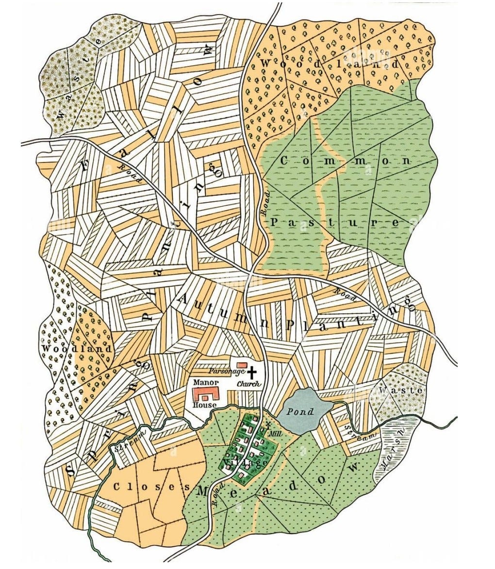
The characteristic features of the open-field landscape were (Figure 1):
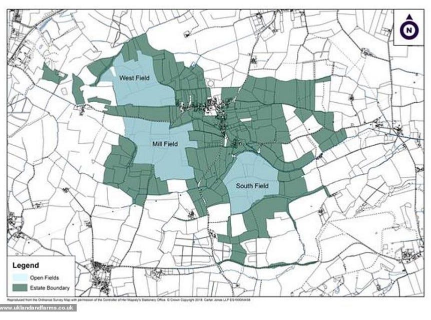
• the establishment of 2 or 3 very large communal open fields around the village, often called North Field, South Field etc.
• strip cultivation within each field, with farmers having access to several strips in each field according to their wealth. Each strip was ideally 22 yards wide (which gave rise to the length of a cricket pitch) and 220 yards long (a furlong in horse-racing). Each field would have a period of fallow every 2/3 years.
• houses collected in a central village, with the landowner living in the village or nearby in the manor house.
• a village church, rectory and surrounding glebe land (land reserved for the parish priest).
• common pastures, often meadows and other low-quality land, with common grazing rights for all on these lands.
• surrounding areas of uncleared woodland where coppicing (cutting a tree at its base to encourage new growth) and pollarding (pruning a tree at a height to encourage a head of foliage) would take place, and pigs and other foraging animals could graze (called swine pastures)
• outlying cottages inhabited by squatters and woodmen each of which had a role to play in the life of the village.
• a series of winding lanes would emerge from the village and provide a link to other settlements in that area.
Advantages of the open field system:
• The quality of the land was evenly spread amongst the farmers of the village. All farmers had a fair share, in theory, of poor- and high-quality land.
• Pressures of mutual support encouraged communal activities, and hence it was easier for the Lord of the Manor to control the activities of the local farmers.
Disadvantages of the open field system:
• A great deal of land was wasted by walkways (balks) and boundaries between fields and between individual strips.
• Much time was lost travelling to individually owned strips in each of the larger fields.
Figure 1. Stylised diagram of the open field system
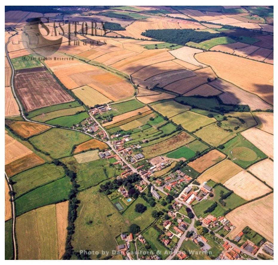
Laxton, Nottinghamshire
The village of Laxton in Nottinghamshire still shows much evidence of the open field system that existed there (Figure 2).
Figure 2. Laxton, Nottinghamshire
Aerial photograph of Laxton