


The 2025 Los Angeles fires, and the wider implications regarding insurance
Part 1 – the fires.

[This is a two-part post looking at the 2025 Los Angeles wildfires. This post examines the causes and some consequences. The second post will look at the long-term implications of the fires (and other climate change related incidents) on the American insurance industry.
Welcome to the 100+ new subscribers over the past week.]
At the end of January 2025, the Los Angeles County Medical Examiner updated the death toll from that month's destructive southern California wildfires to 29. Several wildfires had broken out around the city, two of the largest and most destructive being the Palisades fire to the west of the city, along the Pacific coast, and the Eaton fire to the north of the city.
There have been 17 deaths related to the Eaton fire and 12 deaths related to the Palisades fire. The Palisades Fire in Los Angeles County (LA) burned over 23,000 acres, and the Eaton Fire over 14,000 acres (Figure 1). More than 10 million people in the region were affected amidst gusty winds (the Santa Ana winds) and extremely dry air. Tens of thousands of people have also been displaced for months and now find their housing situation beyond their control. Many thousands of houses were destroyed by the fires. Fire crews say it may take months to clean up toxic contamination from chemicals released as flames consumed electronics, metals, plastics and paints.
You can examine more on the effects of the Palisades fires, including its burnt ‘footprint’, here.
Similarly, there is more on the burnt ‘footprint’ of the Eaton fire here.
Figure 1. The Palisades and Eaton fires – January 10th 2025

Source: NASA
Several aspects have been stated to be causal factors, and this post seeks to examine them. As with many other wildfires, it is the combination of these factors that appears to be the main reason. The official cause of both major fires in LA does however remain under investigation.
The Santa Ana winds
Powerful Santa Ana winds (described by some as hurricane force) and a lack of rain created ‘critical’ fire weather conditions in Southern California. Santa Ana winds typically occur between October and January when a pressure gradient builds up between the central Great Basin to the east and the cool Pacific Ocean to the west. The weather pattern sends gusty, dry winds streaming down the side of inland western USA mountain ranges, through narrow mountain canyons, and towards the Californian coast.
Drought
Although windy conditions are typical this time of year, a lack of rain contributed to the dangerous fire weather. Since October 2024, Southern California received negligible rain, the region has experienced the driest start to the winter on record. Los Angeles airport, for example, recorded 0.08cm of rain since October 1 (the start of the water year in the state) making it the area’s driest start to the water year based on records maintained by the National Weather Service dating back to 1944.
Fuel
The hills around LA had ample fuel available to feed a wildfire. Consecutive wet years in California led to extensive grasses and chaparral (shrubland) accumulating in the mountains and foothills near the city. Warm, very dry weather in Los Angeles during the last eight months of 2024 then followed and left this vegetation ready to burn. The rapid swing from wet to dry conditions can amplify the risk of wildland fires and has become more common in the 21st century. This ‘swing’ has been attributed to climate change.
The 2022-2023 water year, which runs from October to September, saw several ‘atmospheric rivers’ that delivered torrential rain to California. Much of the 2023-2024 water year was also wet, and rainfall totals for both periods were nearly twice the long-term average (1877-2024).
The ample rain allowed vegetation to build up, which is apparent in Figure 2. It shows a satellite-based index of plant health, or ‘greenness’, over the meteorological summer before the fires (the darker the green, the more ‘lush’ the vegetation in the summer).
Figure 2 indicates that many parts of Los Angeles County were 30% greener than average in summer 2024 (compared to a record from 1991 to 2020). The National Interagency Fire Centre noted that ‘herbaceous fuel loadings’ were above normal throughout California, and in some hilly areas, were twice the normal amount.
Figure 2. Plant health around LA (June 1st – August 31st 2024)
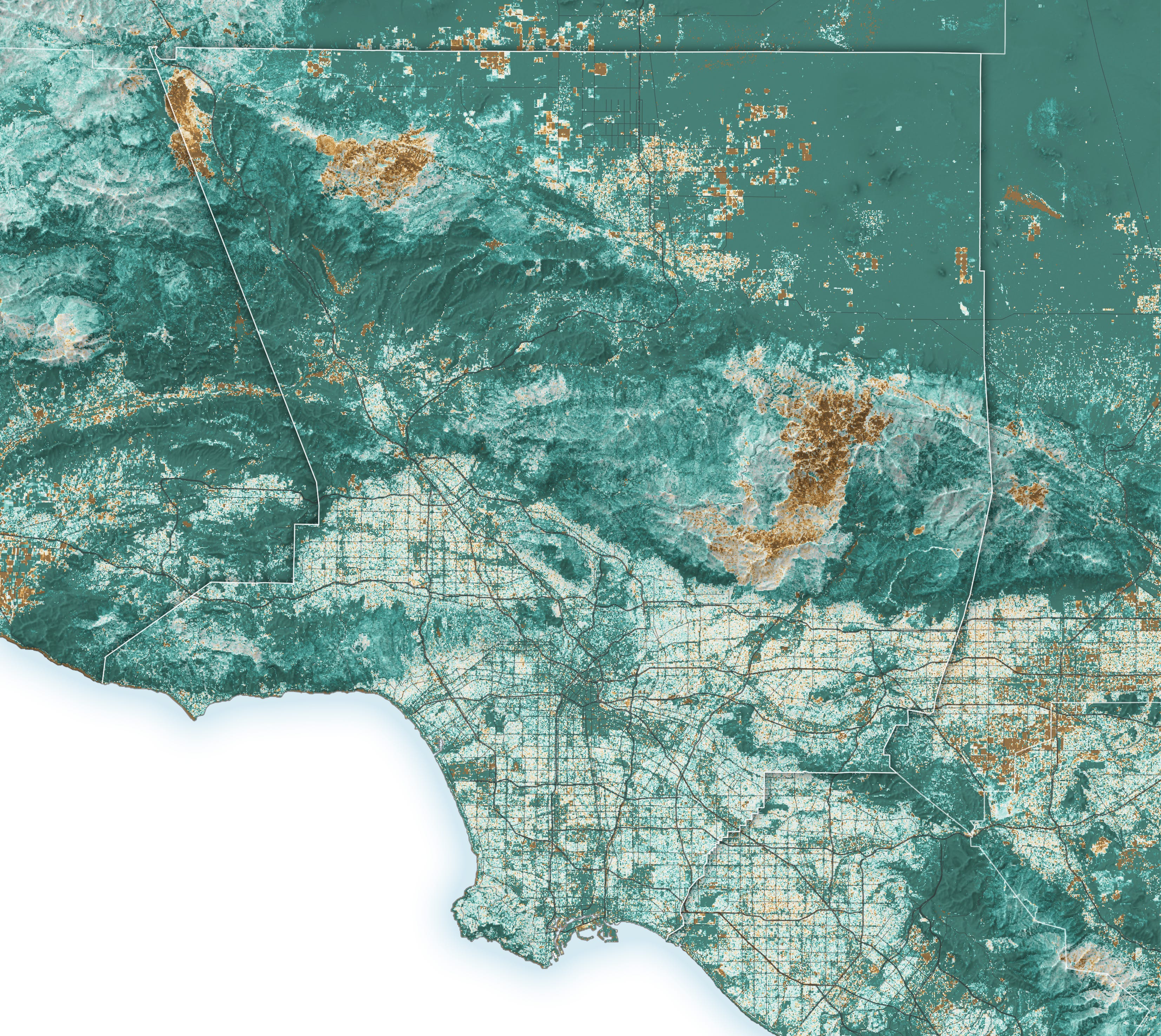
Source NASA
Not only was the vegetation exceedingly dry, so was the immediate soil beneath. Figure 3 shows moisture relative to normal in the top 1m of soil, the ‘root zone’, in early January 7, 2025, the day the Palisades and Eaton fires ignited (the darker the red colour, the drier the soil). The soil moisture in much of Southern California was in the bottom 2% of historical records (1981-2013) for that day.
Figure 3. Soil moisture in LA (January 7 2025)
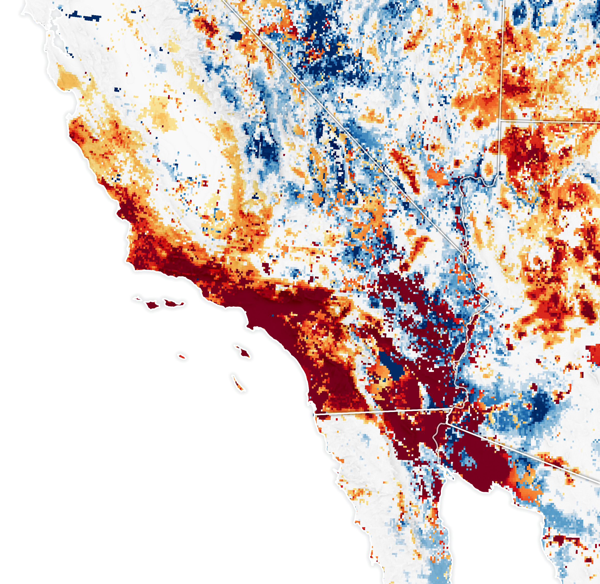
Source: NASA
Electrical spark
A lawsuit alleges the Eaton fire in Altadena, California, was started by an electrical spark from a utility transmission tower belonging to the utility company Southern California Edison, supported by a video according to the law firm bringing the case. As stated above, this is all subject to further investigation.
Health aspects
It emerged that a plume of nitrogen dioxide (NO2) appeared over LA and lingered over the city (Figure 4 - left). As well as the fires, motor vehicles are major sources of the gas in LA, though other main sources include power plants, port facilities, and industrial sites. This plume was accompanied by a variety of other trace gases and airborne particulates also found within wildfire smoke plumes. Among these other gases were elevated levels of carbon monoxide, formaldehyde, and fine particulate matter (PM2.5).
Figure 4. Nitrogen dioxide plumes over LA (January 2025)

Source: NASA
By January 12th (right), firefighters had made enough progress that the NO2 concentration from the fires reduced and urban pollutants began to dominate emissions again.
You can read more about the health aspects of the LA fires here.