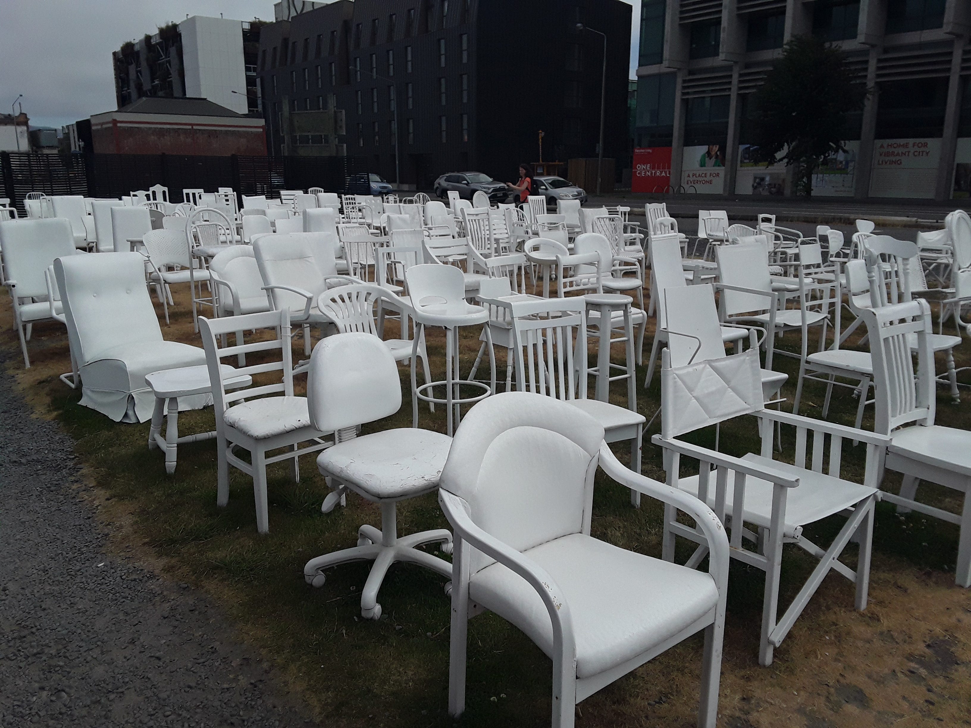
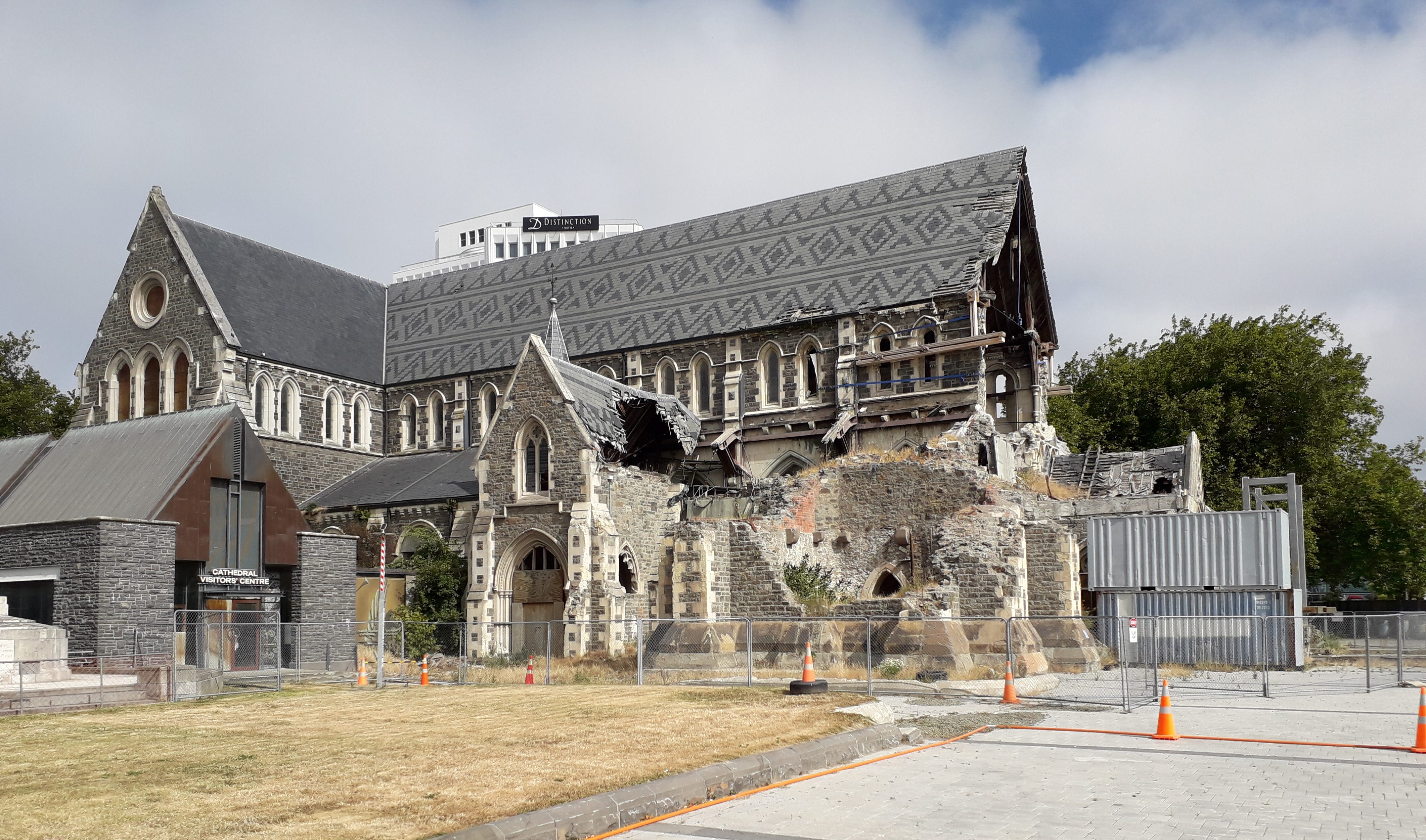
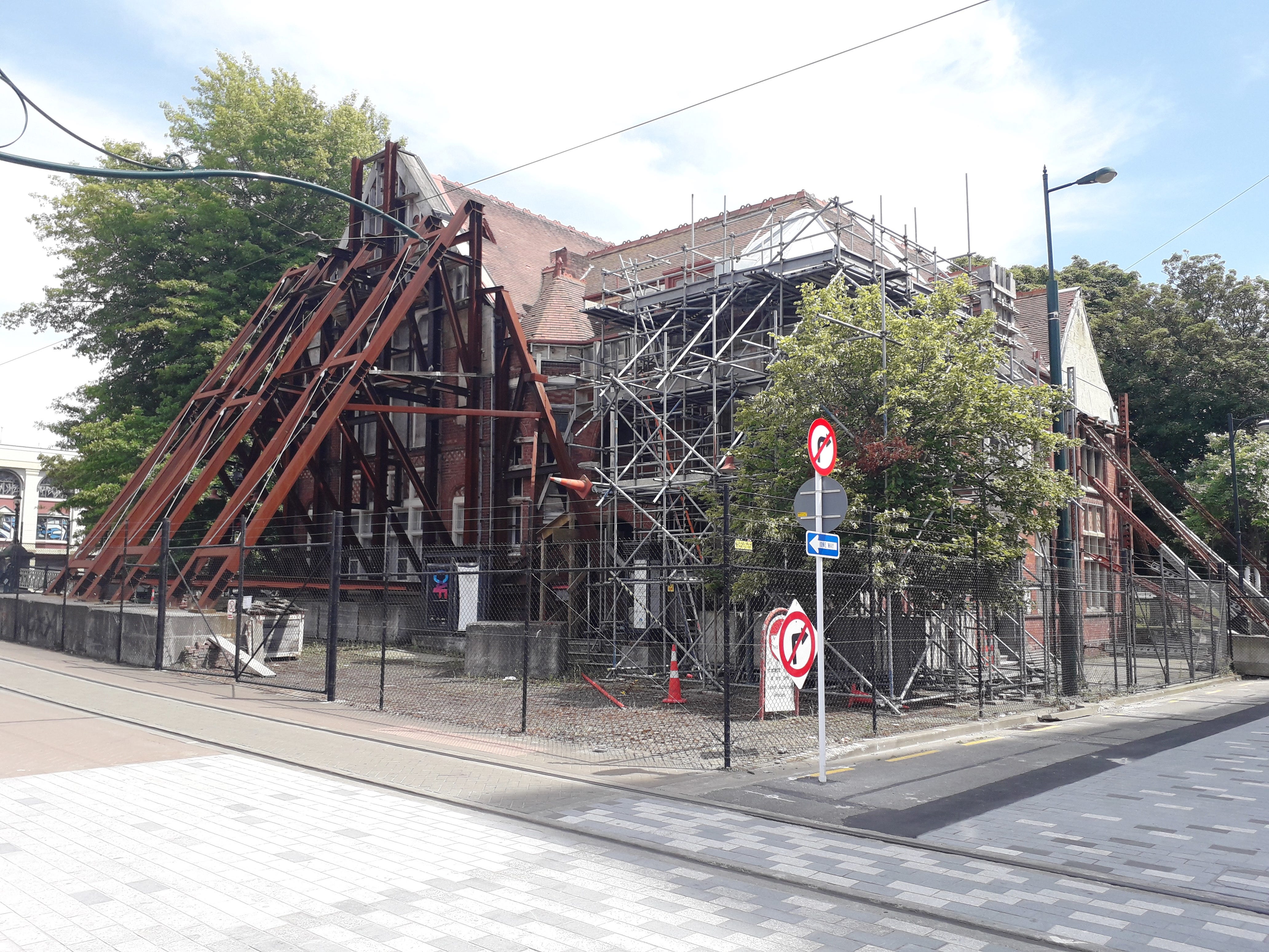
I visited Christchurch in January 2020, just as the Covid-19 pandemic was initiating. The city (it is the size of a small UK town) is an unremarkable place, spread out over a flat plain with a hilly area to the south, towards the coast. The Botanical Gardens and the Hagley Oval cricket ground (and surrounding park) are perhaps the most attractive parts of the city. There were several open spaces within the city centre, where buildings had been removed, including the former Canterbury Television building, now marked by the 185 Empty Chair memorial. The old, damaged, Christchurch Cathedral stands, fenced off, in much the same state as it was in February 2011. Several damaged buildings remain, supported by scaffolding.
Thanks for reading David Redfern's Substack! Subscribe for free to receive new posts and support my work.
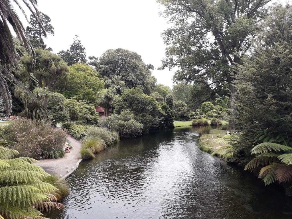
The Botanical Gardens, Christchurch
Photo: Michael Redfern
The 185 Empty Chair memorial
Photo: David Redfern
Tectonic background
New Zealand is located along a section of the Pacific Ring of Fire where the Pacific plate is converging with Indo-Australian plate. Subduction along this boundary is responsible for volcanic activity in the North Island, which is also the location of New Zealand’s major earthquakes. New Zealand experiences between 10000 and 15000 earthquakes each year, of which around 100-150 are large enough to be felt, with several exceeding magnitude 6. The South Island is less seismically active than the North Island and experiences fewer earthquakes of a high magnitude. The interaction of the Pacific and Indo-Australian plates in the South Island has resulted in the major Alpine and Hope fault lines. It is movement along these faults, strike-slip faulting, and numerous smaller faults that causes the South Island’s earthquakes, including the 22 February 2011 Christchurch earthquake.
New Zealand’s tectonic background
Nature of the event
An earthquake had taken place in the region earlier in September 2010. The greater Darfield earthquake, epicentre 40 km to SW of Christchurch, took place at 4.35am on September 10th, 2010 (7.1MMS scale). It caused only one death but caused $4 billion NZ of damage with 350,000 people experiencing 33 seconds of severe ground shaking, laterally offsetting roads, hedges and fences up to 4m with a complex movement of faults erupting at the surface.
The 22 February 2011 earthquake was 6.3MMS, 10 times smaller, but occurred in daytime. It resulted from movement along a previously unknown fault line, 15km in length, running approximately east-west and located to the southeast of Christchurch. Some geologists state that it was an aftershock of the previous Darfield earthquake. A strike-slip fault resulted in movement both east and west, although there was also upward movement (reverse thrust) along the fault line. The relatively shallow (5 km) depth of the earthquake meant that, even though its magnitude was lower, it was destructive. The February earthquake’s epicentre, in the Port Hills, 10 km southeast of the centre of Christchurch, was also much closer to the city. This earthquake itself produced over 300 aftershocks, the largest of which, in June 2011, again measured magnitude MW6.3.
Both the location of the epicentre and the geology of the Canterbury Plains on which Christchurch is located compounded the destruction caused by the earthquake. The hard volcanic rocks of the Port Hills resulted in seismic energy being reflected up to the surface. In addition, the fault line which ruptured lies below the alluvial sediments of the Canterbury Plains. Because groundwater levels were close to the surface, ground shaking during the earthquake caused liquefaction, which in turn led to significant damage to buildings and infrastructure.
Vulnerability
New Zealand’s location makes it particularly susceptible to tectonic hazards. However, the country’s wealth, sophisticated monitoring systems and small population of 4.4 million mean that it is much less vulnerable to the impacts of natural hazards than countries such as Haiti. A national network of instruments and data centres, GeoNet, detects and monitors earthquakes and other hazardous events, and can provide information to emergency services within minutes of a major earthquake. Funding for GeoNet is provided by an Earthquake Commission, established by the government to provide earthquake insurance to homeowners.
The commission is also responsible for public education, including a campaign designed to encourage New Zealanders to ‘Quake Safe’ their homes. New Zealand adopted a building code for earthquake-resistant buildings as early as 1935. Codes are designed to protect buildings from structural damage during moderate earthquakes and, in the case of major earthquakes, to ensure that buildings do not collapse, and people can escape, even if a building is badly damaged. Older buildings have had to be reinforced, although only in the more earthquake-prone North Island. In the South Island, such strengthening was not seen as essential, so Christchurch’s heritage buildings were much more vulnerable.
Impacts of the event
New Zealand’s preparedness was not able to prevent the deadly consequences of the February earthquake:
· In total 184 people were killed, with over 1500 injuries
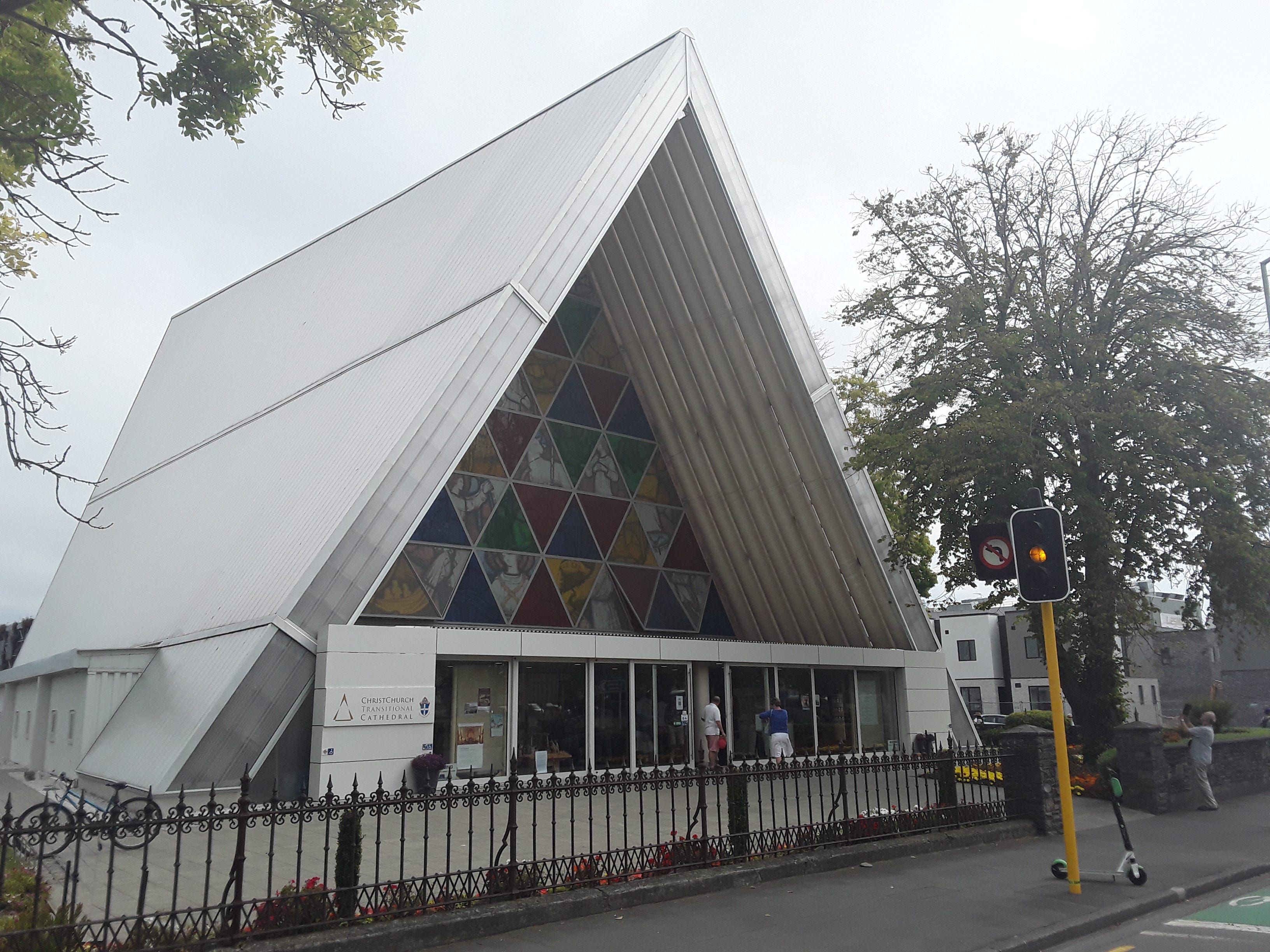
· Many buildings which had already been weakened by the September earthquake collapsed. As the peak ground acceleration was 1.8 times that due to gravity, the shaking intensity led to enormous damage to the city’s buildings, around half of which were destroyed or severely damaged. Most disastrously, the six-storey Canterbury Television building collapsed, killing 85 people. The six-storey PGC House also collapsed, killing 18 people, and Christchurch’s tallest building, the 26-storey Hotel Grand Chancellor, was displaced half a metre by the earthquake, and had to be subsequently demolished. The destruction of many iconic buildings, such as the cathedral in the heart of Christchurch, now replaced by the ‘cardboard cathedral’, lowered the morale of many citizens. More than 150,000 homes and other buildings in Christchurch were severely damaged or destroyed by the earthquake, and more than 100 additional buildings were damaged beyond repair by an aftershock in June 2011
Christchurch cathedral
Photo: David Redfern
The ‘cardboard cathedral’
Photo: David Redfern
· Liquefaction was widespread and severe in Christchurch. It has always posed a risk to the city as large parts are underlain by soft sediments, but the problem in 2011 was exacerbated by the unseasonal high-water content of the substrata. Several conditions determine the likelihood of soils liquefying during an earthquake. These include soil properties such as grain size, the water content of the soil and the severity of the earthquake. During an earthquake the individual soil particles become re-arranged. The resultant shrinkage of the pore spaces causes water to be squeezed out. In built up areas liquefaction can result in the destruction of infrastructure such as roads, pavements, and underground pipes. Rupturing of pipes in Christchurch resulted in many schools being closed even though the buildings were relatively intact. Furthermore, because the soil mass becomes compacted and decreases in volume, subsidence is common. The ground can also shift sideways, a process known as lateral spreading
· There was also almost total destruction of utilities, with a need to build 100km+ of water mains, 400km of sewers and 1000km of roads
· The earthquake also resulted in significant slope failure in the south-eastern upland Port Hills area. The volcanic rocks forming this southern region have steep slopes. Some are remnants of ancient sea cliffs and are almost vertical. These areas experienced rock and debris falls that caused both fatalities and considerable damage to properties adjacent to the cliff base.
· In the worst affected areas, some communities have broken apart as people have been forced to move elsewhere. Four months after the earthquake it was estimated that about 50,000 Christchurch residents had already moved permanently to other parts of New Zealand or to Australia. However, measuring migration is a difficult and complicated process and undoubtedly some people have returned or will return in the future. Indeed, 2012 saw a net increase in migration from overseas due at least partly to employment opportunities in the recovery effort.
· In September 2012 the Education Minister announced that 13 schools would close and 18 merge as a result of the earthquake. The government intends to spend NZ$1 billion in the next 10 years renewing the education system in the affected areas. The reorganisation is a result of a repair bill of NZ$750 million and the loss of 4500 pupils due to outmigration.
· The psychological impact of the earthquake, and the many aftershocks, is perhaps the most difficult aspect to assess. For some individuals the 2011 event itself and the fear of another major earthquake have had a deep impact on their lives. For businesspeople, located both within the area and outside, such a catastrophic event can significantly impact on decisions to invest in the region. Some potential tourists have undoubtedly thought twice before visiting.
· The total loss to the New Zealand economy is estimated to have been NZ$16billion, which amounts to about 13% of GDP.
Responses to the event
Following the September 2010 and February 2011 earthquakes, the government established the Canterbury Earthquake Recovery Authority (CERA) to spearhead the reconstruction of Christchurch. The estimated cost is £13 billion. In the first few months much of the CBD was converted into a complex of container boxes, each replacing services such as shops, banks, and even fast-food outlets. The city was divided into two zones based on the amount of damage, the cost of rebuilding and the ability of the land to sustain future earthquakes:
· The Red zone - these were the worst affected residential areas. Many extend along the valley slopes of the river Avon from the Bexley wetlands at the Avon estuary to Avonside, close to the inner city. Land in this area suffered considerable lateral spreading associated with liquefaction. Here, the government has agreed to buy over 5000 of the worst-affected insured properties or the land on which they are built, based on the 2007 rateable value. Under the scheme these homes could not be repaired for at least 3 years. Areas in the flat land residential red zone have land and infrastructure damage, and an engineering solution to repair them would be uncertain, costly, and likely to be highly disruptive. In the Port Hills area of the city, red zones are those that are either affected by cliff collapse and there are immediate risks to life or affected by rock roll and the risk to life is considered unacceptable. In both cases land remediation is not considered viable, and infrastructure would be difficult and costly to maintain. Also, protective works to mitigate the safety risk are not considered practicable.
· The Green zone - about 100,000 homes are located here, and these are likely to be rebuilt.
Damaged building in the Red Zone
Photo: Michael Redfern
The most common way to reduce the impact of liquefaction is to increase the strength of foundations. This can involve sinking deeper piles. Part of the AMI rugby stadium, for example, was reinforced by a network of 10m stone columns covering an area of over 12000 m2. Unfortunately, even this was not enough to prevent subsidence of two stands by around 40cm. Structural engineers are now considering driving piles down 25 m to reach solid ground.
In December 2013 CERA published its Land Use Recovery Plan - ‘The Land Use Recovery Plan is a major milestone in the rebuild process following the Canterbury earthquakes. It puts land use policies and rules in place to assist rebuilding and recovery of communities (including housing and businesses) disrupted by the earthquakes.’ Note that the Plan did not cover the future use of land in the areas known as the red zone. There have also been issues regarding the slowness in settling insurance claims.
Update:
CERA was disestablished on 18 April 2016 as the Government transitioned from leading the recovery, to establishing long-term, locally led recovery and regeneration arrangements. Most of CERA’s functions have wound down, with many responsibilities carried out by local and central governmental agencies. The organisation Regenerate Christchurch, which was responsible for developing regeneration plans and strategies in the central city, residential red zone, New Brighton, and other potential regeneration areas was also disestablished in June 2020.
Thanks for reading David Redfern's Substack! Subscribe for free to receive new posts and support my work.