


The Maui wildfire, Hawaii – August 2023
A natural- or human-made disaster?

[Welcome to the new subscribers in recent weeks - you have joined a group of over 1,800 geographers. There has been a little debate on ‘X’ here in the UK over the suitability of ‘zombie case studies’ - case studies that are allegedly past their sell-by date. I believe we should make use of the most appropriate case studies, irrespective of their age. You can’t ‘beat’ Mt St Helens!
I don’t think this one is a ‘zombie’ though….]
Introductory summary
The Maui wildfires in August 2023 were the result of a combination of factors:
Weather conditions - the fires were driven by a mix of atmospheric conditions that create ‘fire weather’. These included strong winds and low humidity in an area of very dry weather. Much of Hawaii was already under a red flag warning for fire risk when the wildfires broke out.
Hurricane Dora - the strong winds were caused by Hurricane Dora, a category 4 storm that move across the Pacific ocean, south of the Hawaiian Islands. As the fires grew, they were buffeted by extreme winds caused by the hurricane. Those winds also battered power lines on the island, with some being toppled in the gusts.
Possible electrical causes - investigators examined the possibility of whether downed power lines played a part. The decision-making of the power company Hawaiian Electric was also questioned.
Climate change? Some people state that the fires were a symptom of climate change. There is little direct evidence that this is the case, other than possibly being responsible for the dry vegetation in the area. However, this was more likely due to the prevailing weather conditions that lasted several months.
More detail
The exact cause of the fires has not been officially determined and an investigation is still taking place. The fires also illustrate several issues associated with natural hazards – accuracy of death tolls, how to explain causes, and to what extent is a seemingly natural disaster more a human-made disaster?
Death toll
The final death toll of the fire that destroyed the town of Lahaina has been given as 99. The number of missing was given as 66. This latter figure is difficult to verify as some bodies may never be found, as many ran into the sea to escape the blaze. Furthermore, some people were tourists who would have left the area, and some locals may also have decided to leave the area. It is true, though, that the wildfire was the deadliest in modern US history.
A tinderbox
Even before the winds from Hurricane Dora fed the flames on Maui, a dangerous combination of drought and dry grasses had transformed the island into a tinderbox.
Hawaii was in the middle of a long drought, with parts of Maui suffering from very severe conditions. People had also introduced non-native fire-prone grasses and shrubs that now cover nearly a quarter of Hawaii’s total land area. These grasses are extremely flammable.
Hawaiian Electric
Much of the attention in the wake of the fires focused on power lines that fell amid the area that burned to the ground. The utility company Hawaiian Electric said downed power lines caused a fire during the early morning of August 8, but were not responsible for the afternoon fire in the town of Lahaina that destroyed the town. The company insists that power lines in West Maui had been de-energized for more than six hours by the time a fire began in the Lahaina area.
Blocked roads
Several people died in their cars, trying to escape the fire. With just two major roads providing an exit out of the town - the Lahaina Bypass and the Honoapiʻilani Highway - there were few options for people to evacuate in the case of an emergency. (Figure 1)
Figure 1. Satellite image of Lahaina

Several people opted to leave by these main highways by taking the Lahainaluna Road that connects the above two roads. However, at its intersection with the Honoapiʻilani Highway, the road was closed. Here, police directed cars on to Front Street, which runs parallel to the shoreline, and it became a ‘parking lot’ of cars. Many were stuck for nearly two hours in the traffic jam.
The town had an emergency siren, but it wasn’t activated. Many people decided to evacuate when they could see the smoke billowing around them. Consequently, traffic was very dense – bumper to bumper according to eyewitnesses. As explained above, Maui Police had blocked many roads, adding to the congestion. They say they did this for two reasons: to stop people driving into the path of the fire, and to prevent people from driving near downed power lines. Police said they were simply trying to stop people from getting electrocuted. But, as stated above, Hawaiian Electric said that the power was switched off that morning at 6:40am when a brush fire was first reported.
Maui police have disputed this. ‘Without clear and definitive confirmation that its downed power lines were not energized, Maui's police officers took reasonable precautions to avoid sending evacuees into potentially electrified lines’ Maui's police Chief has said. It is clear the fire spread more quickly than anyone could have expected. With the intersection between Lahainaluna Road and the main highway out of town blocked off, many found themselves cut off from escape (Figure 2).
Figure 2. Burned-out cars on Front Street
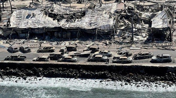
Image - Reuters
Lack of alarms and ineffective fire hydrants
As flames spread through Lahaina, critical systems for evacuating residents and fighting fires – the emergency alerts network and fire hydrants – broke down. Locals complained about a lack of alerts and warnings in the hours leading up to the fire. There were 80 outdoor sirens to alert residents to tsunamis and other natural disasters on the island. However, they were silent as people fled for their lives.
Several firefighters who fought to contain the flames also said that they struggled with fire hydrants running dry or having weak water pressure, complicating an already perilous operation.
Aftermath
Lahaina residents were able to return to their burned-out neighbourhoods over a month after the fires destroyed most of the town. Maui County police warned that ‘many dangers remain’ as burn sites could still be covered with hazardous materials like ash and other debris, such as asbestos, heavy metals and other chemicals. The disaster area was split into zones, which were gradually reopened to residents as they were inspected and deemed safe to re-enter.
The economic costs are estimated to up $6billion according to the US credit rating agency Moody’s. More than 2,200 structures were damaged or destroyed and over 2,000 acres burned, according to FEMA and the Pacific Disaster Center. However, approximately 75% of the losses will be covered by insurance because of the island's high insurance rates. Most of the losses are concentrated in Lahaina, Moody's has said, where insured property value ranged from $2.5 billion to $4 billion. Beyond the emotional toll from the fires, experts also say Maui's rebuilding effort will be more expensive because construction costs are up to 50% more in Hawaii compared to the mainland USA.