


The Quaternary Ice Age
And, the last ice sheet over the British Isles

[This is the first of a series of bite-sized posts on the glaciation of Britain and Ireland. I find this information difficult to process in totality, and I believe students do too. Hence the topic will be examined in chunks.]
There have been several ‘Ice Ages’ throughout geological history. The most recent Ice Age occurred during the Quaternary geological period, which extended from 2.6 million years ago to the present. The Quaternary comprises two geological epochs:
· the Pleistocene, which lasted from the beginning of the Quaternary until about 11,700 years ago (11.7kya)
· the Holocene, which lasted from then until the present.
Some geographers consider that we have recently entered a new epoch, the Anthropocene, dominated by the effects of human activity. Others believe that this term should only be used informally.
The Quaternary Ice Age was characterised by numerous switches (now thought to be over 50) between cold glacial stages and temperate interglacial stages. The most recent glacial stage began about 116kya and is known in Britain as the Devensian. The Late Devensian comprised three substages:
· the Dimlington Stadial (32 to 15kya), a period that marked the expansion, culmination and then shrinkage of the last British Irish ice sheet
· the Late glacial or Windermere Interstadial (15-13kya), a cool temperate interval when glaciers largely or completely disappeared from Britain
· the Loch Lomond Stadial (13-11.7kya), when a large icefield re-occupied the western Highlands of Scotland and smaller glaciers developed in outlying areas.
The last major ice sheet over the British Isles
This last major ice sheet grew to over 1,500m thick some 27,000 years ago (27kya) and was about 25% of the size of the present-day Greenland ice sheet. Once melted, it raised global sea level by nearly 2 metres. The current British landscape has been largely shaped by this ice sheet. The extent of the ice sheet is shown in Figure 1.
Figure 1. Extent of the ice sheet over the British Isles – 27 kya

Early in the last glaciation, enormous ice sheets grew over Canada and Scandinavia, storing huge volumes of water and making sea level much (>100 m) lower. By 31kya most of the North Sea had become dry land while the British and Irish ice sheets were still small. Later in the glacial period and by 27kya, the much larger and heavier British Irish ice sheet had weighed down the land surface locally - by isostatic loading – such that much of it was below sea level. As such ice sheets grounded below sea level are vulnerable to rapid collapse, most of the ice had gone by 15kya. Then, slowly the land surface rebounded upwards, revealing much of the topography we see today.
[You can produce the image shown in Figure 1, and others, including maps of glacial landforms and making use of GIS data, for yourself at www.briticemap.org.]
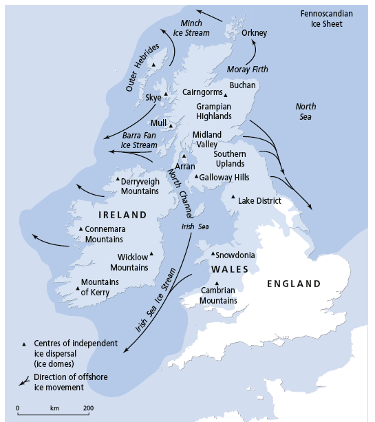
An alternative version of Figure 1, with labels of today’s mountains and past directions of ice flow is below:
I do enjoy your posts. You have really brought the Ice Age alive in a simple form - the maps are good, the visuals help. The timescale is just overwhelming.
I share your posts with non Geographers too. I love how you tackle contemporary issues. Many thanks.
(I'm a retired Geography teacher but still tutor A level students.)