Tsunami account for 7% of tectonic disasters but 36% of deaths (Table 1). Three of the top 10 most deadly disasters in recent years were tsunami (2004 Boxing Day - Banda Aceh, Indonesia; 2008 – Sulawesi, Indonesia; 2011 – Tohoku, Japan).
[Note: all three were on or near the Pacific Ring of Fire.]
Table 1. All Tectonic disasters (2002 – 2022). (EM-DAT)

Characteristics
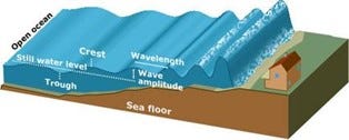
‘Tsunami’ means harbour wave in Japanese, and it is exactly that, a very large wave which floods areas of the coast. When they are out at sea, they have a very long wavelength, often more than 100km. They are very short in amplitude, at around 1m in height. They travel very quickly often at speeds of up to 700kph, for example taking less than a day to cross the Pacific. When they reach land, they rapidly increase in height up to over 25m in some cases. They are often preceded by a localised drop in sea level (drawback) as water is drawn back and up by the tsunami. This is often the first warning of its arrival. It slows down as it approaches a land mass but as the frequency of the wave remains the same, so the height of the wave increases greatly [Figure 1].
When tsunamis hit land, the effect is much more like a flood than a wave. The volume of water, and the long wavelength, means that water is pushed onshore continually and does not drain away, as with the backwash of a normal wave. Most tsunamis are not just one wave, but several over a period of many minutes – this is called a tsunami wave-train. Very large tsunami events such as the 2011 Japanese tsunami or the 2004 Indian Ocean tsunami can have run-up heights of 30m or more. This means a high-water level 30m above average sea level. Hence, if land at the coast is relatively flat, a tsunami can penetrate hundreds of metres inland. In the case of the 2011 Japanese tsunami, some waves reached nearly 10 km inland from the coastline.
Figure 1. Changing characteristics of a tsunami
Causes
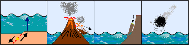
Tsunamis are secondary hazards caused number by several primary hazards such as undersea earthquakes, volcanic collapse, landslides, and even asteroid strikes [Figure 2].
Figure 2. Causes of tsunami
Earthquakes
The most common cause of major tsunami is submarine earthquakes occurring beneath the seabed. Not all such earthquakes generate tsunami. Those that do are called ‘tsunami-genic’ meaning tsunami-causing. To generate a tsunami, the earthquake must cause a vertical displacement of the seabed. This in turn displaces water upward, which generates a tsunami at the ocean surface. Horizontal displacements of the seabed (strike-slip faults) do not tend to generate tsunami.
Volcanic collapse
These most commonly involve the eruption, or emergence, of a volcanic island. There are two main mechanisms:
1. Flank collapse: the landslide of one side of volcano into the sea, displacing water. This is often accompanied by a lateral blast.
2. Caldera collapse: where the upper part of a volcano collapses, accompanied by a massive steam eruption as water contacts magma.
The 2018 Sunda Strait tsunami (Indonesia) involved a volcano. The island of Anak Krakatoa is formed of a volcano that emerged in the sea from Krakatoa’s crater (which famously erupted in 1883) in 1927. There was a flank collapse during the 2018 eruption created a submarine landslide and tsunami 13m high. There were 435 deaths, 14,000 injured and 3000 homes destroyed.
Warning systems
Tsunami cannot be predicted, but earthquakes can be detected & located (using the global seismic monitoring network) allowing warnings to be issued. Additional data can come from DART (Deep-ocean Assessment and Reporting of tsunami) buoys located in the oceans, via satellite. A Tsunami warning station then interprets the data and issues an alert. Such alerts are increasingly App based, but also use text alerts and traditional media. [Figure 3]
Figure 3. DART

Limitations of DART
● Oceans are an extreme environment; the buoys often fail.
● Japan’s system has an annual maintenance cost of US$20 million.
● If the tsunami origin is close to land, a warning may be too short.
● Wave height estimates are not very accurate.
● The system only saves lives alongside an effective dissemination network, and the provisions of evacuation routes/safe places.
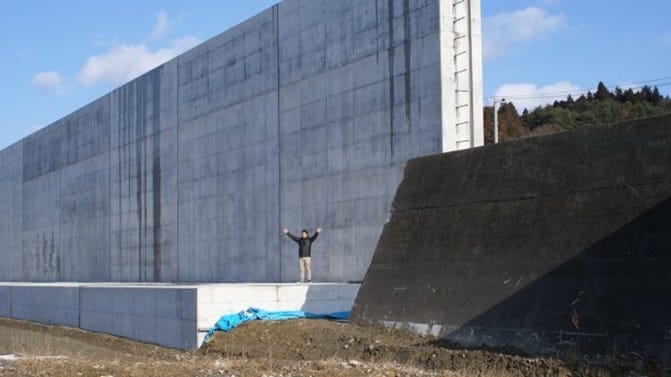
Tsunami engineering: Japan’s Great Wall
Following the 2011 tsunami, Japan has attempted to ‘engineer’ a solution. To prevent tsunami reaching people and property along 400km stretch of Honshu coast it has expanded and increased in size its tsunami wall along the eastern coastline. The cost so far is US$ 15 billion. The barrier is mostly massive concrete tsunami walls, up to 15m high. It effectively cuts people off from the coast, an environmental issue in itself, and one with a huge carbon footprint.
Photo 1. The new tsunami wall

Photo 2. Before (right); after (left)
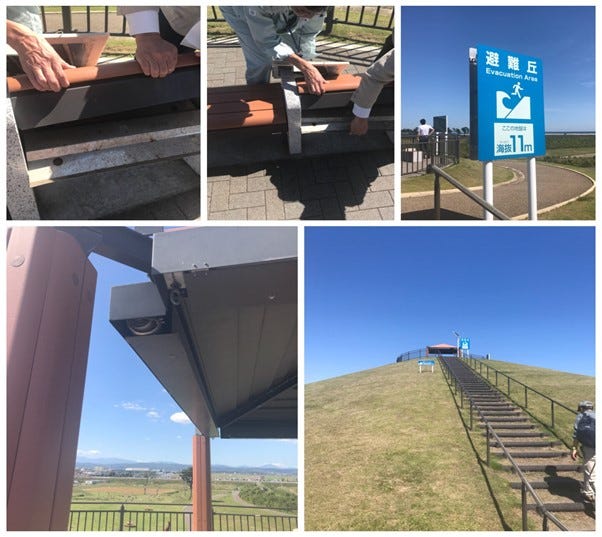
Hills of Life
In some locations, ‘hills of life’ can be found. These have been partly constructed from the debris of 2011 tsunami and provide raised evacuation points for the future. At the top are solar panels, shelter and benches that become stoves in the event of a long stay.
Photo 3. Hills of life